New Excavations at the Brough of Deerness: Power and Religion in
Viking Age Scotland
James H. Barrett1,* and Adam Slater2
Abstract - The grass-covered top of the Brough of Deerness, a small sea stack in Orkney, Scotland, holds the remains of
a substantial Viking Age settlement and associated chapel. The chapel was excavated by Christopher Morris in the 1970s
and discovered to have two phases, one above and one below an Anglo-Saxon coin minted between 959 and 975. New
excavations of two buildings from the surrounding settlement aim to illuminate the function of the site, and to inform our
understanding of the relationship between power and religion during the Viking Age diaspora. At least one of the buildings
was a domestic dwelling, of typical Scandinavian style, abandoned in the 11th to 12th centuries. However, both structures
represent only the top of a long stratigraphic sequence, with underlying middens radiocarbon dated to as early as the 6th to
7th centuries A.D. In its latest phases, the site was probably a chiefl y stronghold (as previously suggested by Morris) with
a symbiotic relationship with surrounding farms. In this preliminary report on new research, several models are tentatively
proposed to account for the role of such a settlement within the political economy of late Viking Age Scotland.
1McDonald Institute for Archaeological Research, University of Cambridge, Downing Street, Cambridge, CB2 3ER, UK.
2Cambridge Archaeological Unit, Department of Archaeology, University of Cambridge, Downing Street, Cambridge CB2
3DZ, UK. *Corresponding author - jhb41@cam.ac.uk.
Introduction
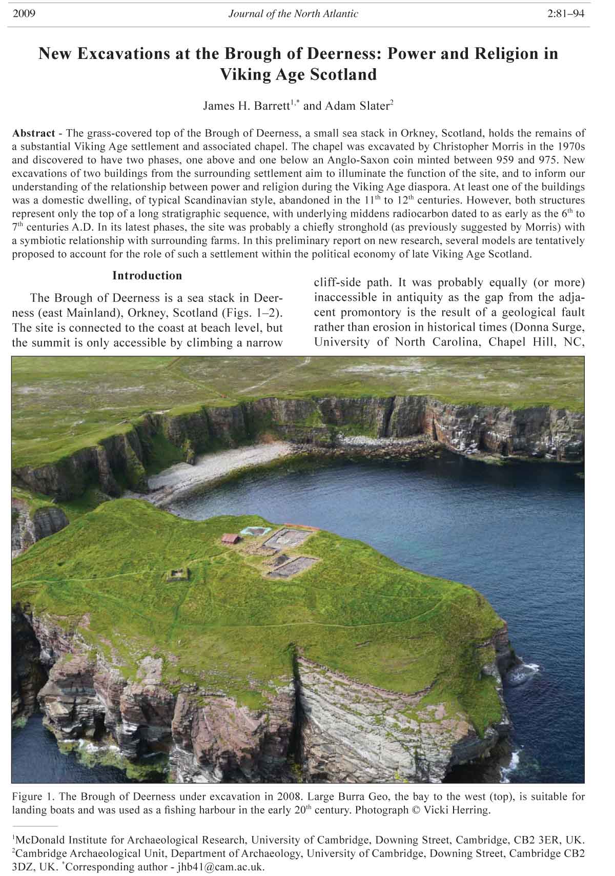
The Brough of Deerness is a sea stack in Deerness
(east Mainland), Orkney, Scotland (Figs. 1–2).
The site is connected to the coast at beach level, but
the summit is only accessible by climbing a narrow
cliff-side path. It was probably equally (or more)
inaccessible in antiquity as the gap from the adjacent
promontory is the result of a geological fault
rather than erosion in historical times (Donna Surge,
University of North Carolina, Chapel Hill, NC,
2009 Journal of the North Atlantic 2:81–94
Figure 1. The Brough of Deerness under excavation in 2008. Large Burra Geo, the bay to the west (top), is suitable for
landing boats and was used as a fi shing harbour in the early 20th century. Photograph © Vicki Herring.
82 Journal of the North Atlantic Volume 2
USA, pers comm.). The Brough’s grass-covered top,
surrounded by ca. 30-m cliffs, holds the remains of
an enigmatic settlement—including a chapel and approximately
30 associated buildings—traditionally
interpreted as a monastery or chiefl y stronghold
(Fig. 3). Despite evidence that the stack was used for
target practice in the First and Second World Wars
(Morris and Emery 1986 and references therein), the
outlines of many house foundations remain at least
superfi cially intact.
Past archaeological excavation, directed by
Christopher Morris (Morris and Emery 1986), focused
on the area around the partially upstanding
stone chapel (Fig. 4). Under it was discovered the
remains of an earlier timber chapel, predating a
layer containing an Anglo-Saxon coin (of Eadgar)
minted between A.D. 959 and 975. This chapel is
thus among the earliest known evidence for Viking
Age Christianity in the Scandinavian North Atlantic
region—possibly predating the traditional conversion
date of A.D. 995 (Barrett 2002, Morris 1996a).
At least the timber phase was potentially founded in
the 10th century, accepting that the coin could have
been old when deposited. The overlying stone phase
may have been built in the 11th or 12th centuries, based
on a radiocarbon date of A.D. 1030–1249 (calibrated
at the 95% probability level) on human bone from
a grave that post-dated its construction (see Barrett
2002). The stone chapel is unlikely to date as late as
the 13th century because the entire site seems to have
been abandoned by then. For example, most of the
medieval pottery known from the Brough of Deerness
came from the decay and collapse phases of the chapel
(Barrett and Slater 2008, Morris and Emery 1986).
Although unique in many respects, the site belongs
to a group of early historic (defi ned as the 6th to
12th centuries A.D. for present purposes) islet, promontory,
and stack settlements known from the Northern
Isles, other parts of coastal Scotland, and the Irish
Sea province. A simple typology might classify them
along scales of size and accessibility on the one hand
and secular versus ecclesiastical function on the other.
In terms of size and access, they range from small
low-lying islands such as Iona (O’Sullivan 1999) to
tiny inaccessible stacks such as the “Castle” of Burrian
in Orkney (Fig. 5; Moore and Wilson 1998). In
terms of function, interpretations
tend to vary from aristocratic
strongholds to monasteries—with
the interrelatedness of power
and religion in the early historic
period allowing for ambiguity between
the two (cf. Barrowman et
al. 2007, Morris 1996b).
It is clear that some sites
served as centers of chiefl y power.
Examples include Burghead and
Dumbarton Rock in Scotland and
St. Patrick’s Isle, Peel, on the Isle
of Man. These settlements have
been associated with the kings of
Pictland (Ralston 2004), Strathclyde
(Alcock 2003), and Man
(Freke 2002), respectively. Others
were clearly monastic in focus.
Well-known Scottish examples
include Iona (O’Sullivan 1999)
and Inchmarnock (Lowe 2008).
In the Northern Isles, the bestknown
site is the Brough of Birsay
(Fig. 6). It is a relatively large tidal
islet off the northwest coast of
Mainland, Orkney. Historical evidence
indicates that in the 11th century
it was either the primary seat
of the earls and bishops of Orkney
or part of a multi-focal settlement
(including mainland sites) that
collectively included these funcFigure
2. Northern Scottish sites mentioned in the text. tions (e.g., Crawford 2005, Morris
2009 J. Barrett and A. Slater 83
1996b). Based on archaeological evidence, its role
as a central place may have begun in Pictish times. It
has seen a series of major excavation campaigns (e.g.,
Curle 1982, Hunter 1986, Morris 1996c).
At the other end of the scale, the small inaccessible
sites of the Northern Isles have only occasionally
been the focus of excavation—for understandable
reasons given the logistical problems they
Figure 3. The Brough of Deerness as surveyed by Fred Bettess during the 1970s excavation (Morris and Emery 1986), when
grazing by sheep revealed the outlines of more buildings than can be seen today. The 2008 excavation areas are superimposed.
(We are grateful to the Society of Antiquaries of Scotland and Christopher Morris for permission to reproduce this plan).
84 Journal of the North Atlantic Volume 2
present. The Kame of Isbister in Shetland, where
the outlines of approximately 20 small buildings
have been recorded, was even investigated as part
of the television series Extreme Archaeology, which
sponsored excavation in difficult locations (Anonymous
2003). This work produced a Viking Age
radiocarbon date on charcoal, but no artifacts were
found to further aid interpretation. Raymond Lamb
(1973), once the Orkney Archaeologist, resolutely
surveyed many sites of this kind and was a particular
advocate of a religious model—interpreting
them as isolated monastic hermitages (either of the
Figure 4. The stone chapel at the Brough of Deerness, as consolidated following excavation by Christopher Morris from
1975 to 1977. Photograph © James Barrett.
Figure 5. The Castle of Burrian—a rock stack in Westray, Orkney, that has two house foundations perched on top. It is an
example of the smallest of such sites in Atlantic Scotland. Photograph © James Barrett.
2009 J. Barrett and A. Slater 85
early “Celtic” or later medieval traditions). However,
other interpretations are also possible.
Some small sites may actually, as Lamb (1980)
conceded, represent earlier Iron Age occupation of
limited relevance to the present discussion. Others
may have functioned as defensive refuges and/or
“watch-towers” of early historic date. Small promontories
were used for this purpose in the 12th century
based on both the Orkneyinga saga (composed ca.
1200) (Guðmundsson 1965) and surviving ruins such
as the castle of Old Wick in Caithness (Gifford 1992).
This tradition continued for centuries. Bucholie
Castle, near Freswick in Caithness, is a good example.
It is a 15th-century fortifi cation on a tiny promontory
that may also be the site of the stronghold and
lookout post known as Lambaborg in the Orkneyinga
saga (Barrett 2005, Batey 1991, Gifford 1992; cf.
Barrowman 2008 regarding Dùn Èistean in Lewis).
These northern promontory, stack, and islet
sites—large and small—have the potential to offer
important clues regarding the relationship between
power, religion, and migration (perhaps better understood
as transnationalism—allowing for complex
movement to and fro along networks; see Barrett
2008a, and references therein) in the early historic
period. This is so whether they were centers of “Scandinavian”
lordship, often with associated churches
(as at the Brough of Birsay and St Patrick’s Isle), or
earlier monastic communities welcomed by chieftains
or kings inspired by the example of Christianized
regions such as Ireland and Gaelic Dál Riata in
western Scotland (cf. Carver 2008, Dumville 2002).
In order to realize this potential, it is necessary
to answer two basic questions: what was the chronology
and function of these sites, singly and as
classifi ed groups? Only with these answers in hand
will it be possible to address more complex issues.
For example, did early monasticism precede or follow
other possible “Irish” cultural infl uence—such
as ogham writing (Forsyth 1995) and fi gure-ofeight
buildings (Ralston 1997)—in pre-Viking Age
Orkney? Or later in time, was the adoption of an
indigenous religion—Christianity—by chieftains
of Scandinavian descent of central importance to
the creation of powerful principalities such as the
Earldom of Orkney and the Kingdom of Man? More
holistically phrased, what was the role of religion in
the processes of migration, transnationalism, and the
resulting emergence of new polities?
These questions need to be addressed one site at a
time, setting the evidence from careful stratigraphic
excavation into its wider regional and international
context. The Brough of Deerness is a promising case
study given the combination of a chapel and approximately
thirty associated buildings. During fi ve
weeks of fi eldwork in June and July of 2008, we set
out to explore the state of preservation, chronology,
and function of the site—focusing on the buildings
around the chapel. These have never before been
excavated. What follows is a preliminary description
and interpretation of what was found. It must be read
as an interim statement regarding work in progress.
The Excavation
The Brough is not presently grazed and is thus
overgrown with thick tussocks of turf that hide
low-relief surface topography. Nevertheless, a
Figure 6. The Brough of Birsay—a tidal islet off the north-west coast of Mainland, Orkney. In the 11th century, it was either
the primary seat of the earls and bishops of Orkney or part of a multi-focal settlement including these functions. Photograph
© James Barrett.
86 Journal of the North Atlantic Volume 2
reasonable guide to the location of structures was
provided by aerial photographs from the 1970s, the
1977 earthwork survey (Fig. 3), and both gradiometer
and resistance surveys conducted by the Orkney
College Geophysics Unit in 2006 (Moore 2007,
Ovenden 2008). It was therefore possible to locate
probable building foundations, two of which were
selected for excavation in consultation with Historic
Scotland and the Orkney Archaeologist.
Area A, an intervention of approximately 13.6 m
by 5.8 m, was opened over Structures 23 and 24
as recorded in 1977 (Fig. 3). Structure 23 was not
visible on the surface in 2008, but Structure 24 was
clear as a raised semicircular feature with a diameter
of ca. 4 m. Area A was chosen to:
1) include a building (Structure 23) on the eastern
side of the main trackway running through the
settlement;
2) section what was thought might be a large shellhole
from use of the Brough for target practice
during the First or Second World Wars (Structure
24);
3) include a region of intense geophysical anomaly
and “busy” topography towards the north end of
the Brough. This area clearly has multi-phase
settlement, so it was considered a good place to
begin to look for any pre-Viking Age evidence;
and
4) be well placed for possible later extension, either
southward to include Structures 18 and 19
or eastward to include Structure 25. Structures
18 and 19 are centrally located within the settlement
and oriented at 90 degrees to most of the
other ruins on the Brough. Together they comprise
one of the longest visible house foundations.
The building they represent may thus have
held special importance within the settlement.
Structure 25, if not two contiguous shell-holes,
appears to be curvilinear and may thus represent
a building of Iron Age/Pictish style.
Area B, an intervention of approximately 14.6 m
by 9.8 m (Fig. 3), was opened over Structure 20, one
of a series of parallel buildings along the main path
running through the settlement. Before excavation,
it was thought likely to be single-phase, based on the
clarity of its outline in the earthwork survey, resistance
survey, and aerial photographs. It was chosen to:
1) include a building on the western side of the
trackway;
2) represent a region of less intense geophysical
anomaly and less uneven topography towards
the west and south of the Brough;
3) rescue archaeology close to the cliff edge which
could nevertheless be made safe for both excavators
and visitors; and
4) uncover a house that might be immediately interpretable
after a brief trial-excavation, rather
than obscured by many superimposed phases.
Area A
The 2008 excavation of Area A revealed the general
outline of Structure 23 and demonstrated that
what was recorded in survey as Structure 24 was a
palimpsest of superimposed ancient features rather
than a single building or a large shell-hole from the
First or Second World Wars (Figs. 7–8.)
Structure 23 appears irregular in plan, partly
due to post-abandonment collapse but apparently
also because it was inserted into a space framed by
pre-existing buildings and/or ruins. It was approximately
7.2 m by 3.5 m in internal dimensions. It had
an inner wall face of unbonded masonry, partly cut
into pre-existing deposits and partly set in what was
Figure 7. Plan of Area A showing the destruction phase of Structure 23 and the earlier (radiocarbon dated) middens and
features beyond its eastern end. Image © Vicki Herring.
2009 J. Barrett and A. Slater 87
otherwise an earth and rubble foundation (presumably
for a turf superstructure). Its bioturbated upper
fl oor level included much charcoal. A single small
shell-hole was discovered near the middle of the
building, associated with fragments of shell-casing.
Structure 23 may have had two opposing doorways
near its western gable, but it was not excavated after
we exposed its general outline, so this interpretation
is conjectural. Most work in 2008 focused on the
eastern end of Area A and on Area B (see below).
Structure 24 turned out to be a series of in situ
features of differing dates. The lowest of these were
midden deposits (with good preservation of animal
bone) into which Structure 23 was inserted. The
middens were examined within the constraints of a
small 2-m by 1-m sondage, and were found to overlie
earlier structural features. No diagnostic artifacts
were recovered from Area A, but two samples of
animal bone have been radiocarbon dated to help
guide ongoing excavation. They came from the uppermost
and lowermost excavated contexts of the
middens into which structure 23 was built. These
samples produced dates of A.D. 660 to 870 (sample
SUERC-23655, 1260 ± 35bp) and A.D. 570 to 665
(sample SUERC-23654, 1420 ± 35 bp), respectively,
at the 95% probability level. Neither of the dates
requires marine reservoir correction, being on pig
and cattle bones having δ13C values of -20.7‰ and
-21.6‰ (cf. Barrett and Richards 2004). They imply
the existence of a pre-Viking Age Pictish settlement
on the Brough of Deerness. It remains to be established,
however, whether or not there was continuity
between this ca. 6th- to 9th-century use of the Brough
and the later settlement.
Area B
The 2008 excavation of Area B demonstrated
that Structure 20 (hereafter “House 20”) was a
multi-phase house of Viking Age Scandinavian
style that was abandoned in the 11th to 12th centuries
(Figs. 9–10). It was approximately 10.4 m by 4.1 m
in internal dimensions (after narrowing from a probable
original width of approximately 4.9 m). House
20 overlaid an earlier feature—possibly another
building—the remains of which
were found extending from under
its southeastern corner.
The earliest construction
and occupation phases of House 20
itself have not yet been excavated.
In its penultimate configuration,
however, the building was a threeaisled
house with two rows of roofsupporting
posts and probably also
an internal cross-wall of perishable
material dividing its internal space
into eastern and western rooms. Its
eastern room contained a central
hearth, side aisles (marked out
by the roof-supporting posts and
small edge-set stones) and niches
in the northeast and southeast corners
(also demarcated by edge-set
stones). At some point, a second
hearth was also established near
the eastern end of the building. The
western room was mostly featureless,
but may originally have had
side-aisles. The fl oors associated
with this penultimate phase of the
building’s use produced a glass bead
of 11th-century date. Additional
fi nds from the exterior of House 20,
or from the destruction of its walls,
may be broadly contemporary with
use of the building (if not residual
from earlier Viking Age occupation).
These included a soapstone
Figure 8. The destruction phase of Structure 23 from the southeast. Photograph loom weight and a soapstone vessel
© Brian Rahn.
88 Journal of the North Atlantic Volume 2
of the northern wall (Fig. 13). The northern wall itself
was a rebuild, the original having collapsed earlier in
the life of the house.
shard—the latter of Norwegian style (Figs. 11–12). It
is probable that there were originally two entrances
into the building, in the northwest and northeast ends
Figure 9. Plan of Area B showing the penultimate occupation phase. Note the eight decommissioned post-holes (some
packed with stones) from the original internal roof supports. Image © Vicki Herring.
Figure 10. House 20 in Area B. Photograph © Brian Rahn.
2009 J. Barrett and A. Slater 89
north and south walls. Thus, the life of this single
building encapsulates a change in Scandinavian
architectural fashion dated to the 10th–11th centuries
in Denmark and Norway (if a few centuries later in
Iceland, at least in outbuildings) (Gestsson 1959,
Hvass 1993, Norr and Fewster 2003). Concurrently,
a new entrance was inserted in the center of the
south wall, and a new earth floor with occasional
paving slabs was laid. At this time, or shortly after,
a copper alloy pin of 11th to 12th century date
Late in the use-life of House 20, the internal
posts were removed and their post-holes filled in.
At the western end of the building, this entailed
digging and refilling relatively large and irregular
robbing pits—suggesting that the upright timbers
were very substantial in this part of the house. Elsewhere
the removal of the roof supports left more
discrete post-pipes that were backfilled with earth
and stone. The internal posts seem to have been
replaced with timbers along the inside edge of the
Figure 11. A soapstone loom weight from outside House 20 (scale in cm). Photograph © James Barrett.
Figure 12. A soapstone vessel shard from outside House 20 (scale in cm). Photograph © James Barrett.
90 Journal of the North Atlantic Volume 2
Figure 13. Northeast entryway to House 20, with internal and external threshold stones and fl agstone path. Photograph ©
Vicki Herring.
Figure 14. A selection of fi nds from House 20, including an 11th–12th-century copper alloy pin, a soapstone spindle whorl,
and the single piece of pottery from the building (spindle whorl diameter = 3.5cm). Photograph © James Barrett.
2009 J. Barrett and A. Slater 91
far), small, and discrete. In areas of deep stratigraphy
(where cultural deposits buffer the natural soil
acidity), bone is well preserved.
Secondly, the settlement was long-lived. The
uppermost layers of House 20 probably date to the
11th to 12th centuries, but it has numerous successive
fl oor layers and was remodelled at least twice.
Although we have not yet reached the earliest levels
of this house, its multiple phases point to a long period
of use. Moreover, it appears to have been built
on top of an earlier building, part of which extends
from under its southeast corner. House 23 has not yet
been investigated in such detail, but it too overlies
pre-existing deposits. It appears to have been dug
into middens of ca. 6th to 9th century date.
Thirdly, the settlement was a focus of domestic
occupation. In addition to beads and pins, the site
produced a soapstone vessel shard, a soapstone
loom weight, spindle whorls of both soapstone and
sandstone, and a variety of other domestic objects
(Figs. 11–12, 14–15). These are consistent with
“normal” occupation, perhaps by both men and
women, rather than use as either a temporary refuge
or a monastery. Textile making is associated with
women in late Viking Age sources such as the poem
Darraðarljóð incidentally set in Scotland in Njáls
saga (Magnusson and Pálsson 1960, Poole 1993).
The absence of elaborate stone sculpture
incorporating Christian motifs,
even from the previous excavation in
the churchyard, should also be noted
(albeit with the weakness of negative
evidence). Excavated early medieval
monasteries in Scotland produce
monuments of this kind (e.g., Carver
2008, Lowe 2008). Lastly, the burial
evidence from the cemetery is inconsistent
with an exclusively ecclesiastical
function. Of the six excavated
graves, fi ve were of children, one of
which was newborn (Morris and Emery
1986). At least two of these infant
graves are associated with the earliest
phase of the chapel.It seems likely that
families were living in the settlement
on the Brough of Deerness.
The number of burials around the
chapel is unusually small. It could
therefore not have been in use for
the full duration of occupation on the
Brough of Deerness (given that the latter
is now known to potentially extend
from the 6th to the 12th century). A date
before the 10th century is also unlikely
for a chapel of this kind, based on comparative
grounds (cf. Blair 2005). If it
was only used during the last two cen-
(Fig. 14) and a roughly incised spindle whorl (Fig.
15) were lost in the building.
There were no shell holes in Area B, although
occasional pieces of possible shell casing were recovered.
Bone was not preserved in this area, with
the exception of a few pieces in the ash of a hearth.
The sediments were probably too acid—presumably
because the cultural deposits are shallower in Area B
than in Area A and thus do not adequately buffer the
naturally high pH. It may also be relevant, however,
that House 20 is so close to the cliff-edge. Presumably,
much household refuse would have been discarded
directly into the sea.
Discussion
The 2008 trial excavation at the Brough of Deerness
set out to explore the state of preservation, chronology
and function of the site and thus to evaluate
its implications for the study of power, ideology, and
migration/transnationalism in the early historic period.
The preliminary results are illuminating. Firstly,
the settlement is remarkably well preserved despite
records of shelling for target practice during both
the First and Second World Wars. Wall foundations,
house fl oors, and middens are largely intact. In the
excavated areas, shell holes are few (only one thus
Figure 15. A roughly incised spindle whorl from House 20 in Area B (scale
in cm). Photograph © James Barrett.
92 Journal of the North Atlantic Volume 2
might speculate that these hypothetical chieftains
espoused different religions as their ideological
bases of power (Barrett 2002). The latest possible
pagan burials in Orkney Mainland—particularly
one at Buckquoy coin-dated to the mid-10th century
(Ritchie 1977)—come from the Birsay area. Following
this third hypothesis, it would have been highly
symbolic that Birsay became Orkney’s episcopal
center in the mid-11th century. The bishopric was
established by Earl Thorfi nn (Guðmundsson 1965,
Tschan 1959), the son of Sigurd Hlodvisson, who is
the fi rst Orkney earl whose existence is historically
indisputable. Sigurd died, perhaps under a (pagan?)
raven banner, at the Battle of Clontarf in Ireland in
1014 (Guðmundsson 1965, Hennessy 1998).
Regardless of whether this third hypothesis is
correct, it is clear from the Brough of Deerness and
the Brough of Birsay that the adoption of Christianity,
rather than the maintenance of paganism, was an
important corollary of chiefl y power in Orkney by
the late Viking Age. Of course, this observation applies
for most areas of Northern Europe at much the
same time (e.g., Carver 2002). Depending on how
early it began, however, the association between
chieftains and Christian practice may be the most
lasting evidence for indigenous infl uence on migrant
Scandinavian elites in early historic Scotland.
Acknowledgments
Further details regarding the 2008 Brough of Deerness
excavation can be found in the on-line annual report
(Barrett and Slater 2008) and in a popular article on the
results published in issue 228 of the magazine Current
Archaeology. The excavation was conducted with the
permission of Historic Scotland and the Orkney Islands
Council. It was jointly funded by the McDonald Institute
for Archaeological Research, the Orkney Islands Council,
the Royal Norwegian Embassy (London), and the Norwegian
Consulate General (Edinburgh). Contributions in
kind were generously provided by Orkney College and the
Orkney Museum. Special thanks are owed to Julie Gibson
(Orkney Archaeologist), Christine Skene (Orkney Islands
Council), Anne Brundle (Orkney Museum), Anne Billing
and Isobel Gardner (of The Friends of St Ninian’s), Allan
Rutherford (Historic Scotland), and Christopher Morris
(University of the Highlands and Islands Millennium Institute)
for helping make the project happen. The excavation
crew included Tom Blackburn, Fiona Breckenridge,
Pieterjan Deckers, Paul Ewonus, Katie Hall, Vicki Herring,
Janis Mitchell, Brian Rahn, and Leanne Zeki. James
Graham-Campbell kindly assisted with interpreting the
artifacts. Donna Surge and Michael Mobilia of the University
of North Carolina provided valuable observations
regarding the geology of the Brough. Judith Jesch and
Clare Downham helped encourage this work in its early
stages. Lord Wallace of Tankerness, Morag Robertson,
Stein Iversen, and Mona Røhne generously assisted with
fund-raising. Last but not least, the residents of Deerness
have generously welcomed us onto their lands and into
their heritage.
turies (plus or minus) of occupation, as seems likely,
the small number of associated graves implies either
that the late Viking Age settlement on the Brough
was not continuous, that only a select few (perhaps
members of a single elite family) had burial rights
there, or a combination of these factors.
Given these observations, how might one interpret
the function of the settlement? Hypotheses
regarding possible pre-Viking Age monastic occupation
of “Celtic” type would be very premature,
given that we have just begun to clarify the top of the
sequence which is late Viking Age. The deep stratigraphy
and radiocarbon dates do indicate earlier occupation
levels, but nothing can yet be said about the
character of these phases. Conversely, monasticism
is unlikely for the excavated Viking Age settlement
because the archaeological record from both the past
and present excavations suggests habitation by family
groups and lacks ecclesiastical sculpture.
If not monastic, what was the nature of the settlement?
Christopher Morris (e.g., 1990, 1996a) has
suggested that it should be interpreted as a chiefl y
stronghold with a private chapel, a possibility that
is supported by the new excavation and the obvious
defensive qualities of the site’s location. But how
would a settlement of this type have functioned
within its wider community? Three tentative models
can be proposed.
First, it is possible that the site was one of several
centers used by the earls of Orkney in a peripatetic
system by which they lived off the proceeds of scattered
estates (cf. Alcock 1988, Ralston 2004). Produce
could have been brought to the stack from, for
example, neighboring Viking Age settlements such as
those known at Skaill (Buteux 1997) and Newark Bay
(Barrett et al. 2000, Brothwell 1977). In this eventuality,
the Brough of Deerness would presumably have
been permanently garrisoned, but only occasionally
fully inhabited. If this hypothesis is correct, the site
can perhaps be seen as a rough equivalent of the better-
known elite center of the Brough of Birsay, with
its church and associated settlement. Second, the site
could represent the stronghold of a wealthy magnate
below the level of earl, of the kind well known from
the Orkneyinga saga (Barrett 2007). In this event, the
Brough of Deerness might be imagined as an imitation
or emulation of Birsay.
Alternatively, if the earldom of Orkney was not
established until the early 11th century, as is possible
based on the contemporary historical and archaeological
evidence rather than the later Orkneyinga
saga (Barrett 2008b, Woolf 2007), the Brough of
Birsay and the Brough of Deerness could represent
the strongholds of competing independent chieftains.
Given the possible 10th-century foundation
of the chapel on the Brough of Deerness, and of
a nearby Christian cemetery at Newark Bay, one
2009 J. Barrett and A. Slater 93
tations of so-called souterrains. Bulletin of the Institute
of Archaeology 14:179–90.
Buteux, S. (Ed.) 1997. Settlements at Skaill, Deerness,
Orkney. British Archaeological Reports British Series
260. Archaeopress, Oxford, UK. 276 pp.
Carver, M. (Ed.) 2002. The Cross Goes North. Boydell
Press, Woodbridge, UK. 602 pp.
Carver, M. 2008. Portmahomak: Monastery of the Picts.
Edinburgh University Press, Edinburgh, Scotland,
UK. 232 pp.
Crawford, B.E. 2005. Thorfi nn, Christianity, and Birsay:
What the saga tells us and archaeology reveals. Pp.
88–110, In O. Owen (Ed.). The World of Orkneyinga
Saga: “The Broad-cloth Viking Trip.” The Orcadian,
Kirkwall, Scotland, UK. 232 pp.
Curle, C.L. 1982. Pictish and Norse Finds from the Brough
of Birsay 1934–74. Society of Antiquaries of Scotland
Monograph Series Number 1. Society of Antiquaries
of Scotland, Edinburgh, Scotland, UK. 141 pp.
Dumville, D.N. 2002. The North Atlantic monastic thalassocracy:
Sailing to the desert in early medieval insular
spirituality. Pp. 121–30, In B.E. Crawford (Ed.). The
Papar in the North Atlantic: Environment and History.
St. John's House Papers No. 10, University of St. Andrews,
St. Andrews, Scotland, UK. 447 pp.
Forsyth, K. 1995. The ogham-inscribed spindle whorl
from Buckquoy: Evidence for the Irish language in
pre-Viking Orkney? Proceedings of the Society of
Antiquaries of Scotland 125:677–96.
Freke, D. (Ed.) 2002. Excavations on St Patrick’s Isle,
Peel, Isle of Man, 1982–88: Prehistoric, Viking, Medieval,
and Later. Liverpool University Press, Liverpool,
UK. 405 pp.
Gestsson, G. 1959. Gröf í Öræfum. Árbók hins íslenzka
fornleifafélags 1959:5–87.
Gifford, J. 1992. The Buildings of Scotland: Highlands
and Islands. Penguin Books in association with The
Buildings of Scotland Trust, London, UK. 688 pp.
Guðmundsson, F. (Ed.) 1965. Íslenzk fornrit 34. Orkneyinga
saga. Hið íslenzka fornritafélag, Reykjavík,
Iceland. 428 pp.
Hennessy, W.M. (Ed.) 1998. Annals of Ulster, Volume I.
Éamonn de Búrca, Dublin, Ireland. 269 pp.
Hunter, J.R. 1986. Rescue Excavations on the Brough of
Birsay 1974–82. Society of Antiquaries of Scotland
Monograph Series Number 4. Society of Antiquaries,
Edinburgh, Scotland, UK. 230 pp.
Hvass, S. 1993. Bebyggelsen. Pp. 187–94, In S. Hvass and
B. Storgaard (Eds.). Da Klinger i Muld: 25 års arkæologi
i Danmark. Aarhus Universitetsforlag, Aarhus,
Denmark. 312 pp.
Lamb, R.G. 1973. Coastal settlements of the north. Scottish
Archaeological Forum 5:76–98.
Lamb, R.G. 1980. Iron Age promontory forts in the
Northern Isles. British Archaeological Reports British
Series 79, Oxford, UK. 102 pp.
Lowe, C. (Ed.) 2008. Inchmarnock: An Early Historic
Monastery and its Archaeological Landscape. Society
of Antiquaries of Scotland, Edinburgh, Scotland, UK.
313 pp.
Magnusson, M., and H. Pálsson. 1960. Njal's Saga. Penguin,
London, UK. 384 pp.
Literature Cited
Alcock, L. 1988. The activities of potentates in Celtic
Britain, A.D. 500–800: A positivist approach. Pp.
22–46, In S.T. Driscoll and M.R. Nieke (Eds.). Power
and Politics in Early Medieval Britain and Ireland.
Edinburgh University Press, Edinburgh, Scotland,
UK. 200 pp.
Alcock, L. 2003. Kings and Warriors, Craftsmen and
Priests in Northern Britain A.D. 550–850. Society of
Antiquaries of Scotland, Edinburgh, Scotland, UK.
460 pp.
Anonymous. 2003. Extreme Archaeology: Kame of Isbister,
Shetland Islands. HU 38279152 Archaeological
Evaluation Data Structure Report. Mentorn TV, London,
UK.
Barrett, J.H. 2002. Christian and pagan practice during the
conversion of Viking Age Orkney and Shetland. Pp.
207–26, In M. Carver (Ed.). The Cross Goes North.
Boydell Press, Woodbridge, UK. 602 pp.
Barrett, J.H. 2007. The pirate fi shermen: The political
economy of a medieval maritime society. Pp. 299-340,
In B.B. Smith, S. Taylor, and G. Williams (Eds.). West
Over Sea: Studies in Scandinavian Sea-borne Expansion
and Settlement Before 1300. Brill, Leiden, The
Netherlands. 586 pp.
Barrett, J.H. 2008a. What caused the Viking Age? Antiquity
82:671–85.
Barrett, J.H. 2008b. The Norse in Scotland. Pp. 411–27,
In S. Brink, and N. Price (Eds.). The Viking World.
Routledge, London, UK. 717 pp.
Barrett, J.H., and M.P. Richards. 2004. Identity, gender,
religion, and economy: New isotope and radiocarbon
evidence for marine resource intensifi cation in early
historic Orkney, Scotland. European Journal of Archaeology
7:249–271.
Barrett, J., and A. Slater. 2008. The Brough of Deerness
Excavations 2008: Research context and data structure
report. Unpublished report. McDonald Institute
for Archaeological Research, Cambridge, UK. Available
online at www.mcdonald.cam.ac.uk/projects/
Deerness/Brough_of_Deerness_2008.pdf. Accessed
September 21, 2009.
Barrett, J.H., R.P. Beukens, and D.R. Brothwell. 2000.
Radiocarbon dating and marine reservoir correction of
Viking Age Christian burials from Orkney. Antiquity
74:537–43.
Barrowman, R.C. 2008. Splendid isolation? Changing
perceptions of Dùn Èistean, an island on the north
coast of the Isle of Lewis. Pp. 95–111, In G. Noble, T.
Poller, J. Raven, and L. Verrill (Eds.). Scottish Odysseys:
The Archaeology of Islands. Tempus, Stroud,
UK. 180 pp.
Barrowman, R.C., C.E. Batey, and C.D. Morris. (Eds.)
2007. Excavations at Tintagel Castle, Cornwall,
1990–1999. Society of Antiquaries of London, London,
UK. 370 pp.
Batey, C.E. 1991. Archaeological aspects of Norse settlement
in Caithness, North Scotland. Acta Archaeologica
61:29–35.
Blair, J. 2005. The Church in Anglo-Saxon Society. Oxford
University Press, Oxford, UK. 604 pp.
Brothwell, D. 1977. On a mycoform stone structure in
Orkney, and its relevance to possible further interpre94
Journal of the North Atlantic Volume 2
Moore, J. 2007. Brough of Deerness. Discovery and Excavation
in Scotland, New Series 7:125.
Moore, H., and G. Wilson. 1998. Orkney Coastal Zone
Assessment Survey 1998. EASE Archaeological Consultants,
Edinburgh, Scotland, UK. 344 pp.
Morris, C.D. 1990. Church and Monastery in the Far
North: An archaeological evaluation. Jarrow Lecture
1989. St Paul’s Church, Jarrow, UK. 43 pp.
Morris, C.D. 1996a. Church and monastery in Orkney and
Shetland: An archaeological perspective. Pp. 185–206,
In J.F. Krøger and H. Naley (Eds.). Nordsjøen: Handel,
Religion og Politikk. Karmøy Kommune, Kopervik,
Norway. 211 pp.
Morris, C.D. 1996b. From Birsay to Tintagel: A personal
view. Pp. 37–78, In B.E. Crawford (Ed.). Scotland in
Dark Age Britain. Scottish Cultural Press, Aberdeen,
Scotland, UK. 160 pp.
Morris, C.D. (Ed.) 1996c. The Birsay Bay Project Volume
2: Sites in Birsay Village and on the Brough of
Birsay, Orkney. University of Durham, Department of
Archaeology Monograph Series Number 2. University
of Durham, Durham, UK. 302 pp.
Morris, C.D., and N. Emery. 1986. The chapel and enclosure
on the Brough of Deerness, Orkney: Survey and
excavations, 1975–1977. Proceedings of the Society
of Antiquaries of Scotland 116:301–74.
Norr, S., and D. Fewster. 2003. Borg II. Pp. 109–18, In
G.S. Munch, O.S. Johansen, and E. Roesdahl (Eds.).
Borg in Lofoten: A Chieftain’s Farm in North Norway.
Tapir Academic Press, Trondheim, Norway. 309 pp.
O’Sullivan, J. 1999. Iona: Archaeological investigations
1875–1996. Pp. 215–43, In D. Broun and T.O. Clancy
(Eds.). Hope of Scots: Saint Columba, Iona, and
Scotland. T. and T. Clark, Edinburgh, Scotland, UK.
314 pp.
Ovenden, S. 2008. Geophysical survey. Pp. 7–8, In J.
Barrett and A. Slater (Eds.). The Brough of Deerness
Excavations 2008: Research context and data structure
report: 7–8. Unpublished report. McDonald Institute
for Archaeological Research, Cambridge, UK. Available
online at www.mcdonald.cam.ac.uk/projects/
Deerness/Brough_of_Deerness_2008.pdf. Accessed
September 21, 2009.
Poole, R. 1993. Darraðarljóð. Pp. 121, In P. Pulsiano
(Ed.). Medieval Scandinavia. Routledge, London, UK.
792 pp.
Ralston, I. 1997. Pictish homes. Pp. 19–34, In D. Henry.
The Worm, the Germ, and the Thorn: Pictish and Related
Studies Presented to Isabel Henderson. The Pinkfoot
Press, Balgavies, Angus, Scotland, UK. 200 pp.
Ralston, I. 2004. The Hill-forts of Pictland since “The
Problem of the Picts.” Groam House Museum, Rosmarkie,
Scotland, UK. 53 pp.
Ritchie, A. 1977. Excavation of Pictish and Viking-Age
farmsteads at Buckquoy, Orkney. Proceedings of the
Society of Antiquaries of Scotland 108:174–227.
Tschan, J. (Ed.) 1959. Adam of Bremen. The Archbishops
of Hamburg Bremen. Columbia University Press, New
York, NY, USA. 288 pp.
Woolf, A. 2007. From Pictland to Alba 789–1070. Edinburgh
University Press, Edinburgh, Scotland, UK.
320 pp.